First Look — What Even Is This?
Honestly, I had zero experience with GeoGuesser or GEOINT before this. This was my first CTF and when I saw this challenge, my brain just said — "okay, this is a find-where-this-photo-was-taken game." That's all I understood. No methodology, no prior knowledge of how these challenges work.
So I did the most natural thing — opened the image and just stared at it. No tools, no plan. Just me and a photo, trying to figure out which corner of the world Alan had escaped to.
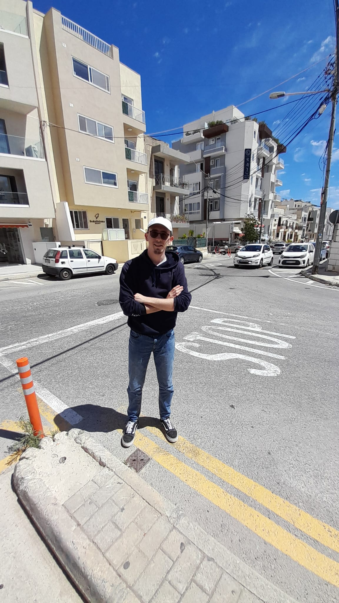
My eyes immediately went to the background buildings — not the person, not the road markings first, just those buildings. Something about them felt very specific. That pale, almost sandy stone texture. Not concrete, not brick — something that felt more natural and regional. I had no idea what it was exactly, but one thing was clear — the background building looked notable and good-looking. People don't randomly stand in front of plain walls for a photo. That kind of background is always intentional, which meant it was worth investigating.
Then I noticed the road. A STOP marking painted directly on the asphalt, double yellow lines along the kerb — and the road layout had this British-influenced feel, like something from an old colonial territory rather than mainland Europe.
Throwing It at AIs — Getting Nowhere Fast
Since I had no idea where to begin, I shared the image with several AI tools to get different perspectives. I figured if multiple AIs agreed on something, that would be a reliable starting point.
What I got instead was total chaos:
Spain. Rome. Romania. Greece. Southern France. Every tool had a completely different answer. None of them agreed. One of them — almost like a side note — mentioned Malta.
I didn't trust any single answer. But this gave me a list of countries to actually investigate myself. So I started manually looking up street photos and architecture of each one and comparing them with the challenge image — Spain, then Romania, then Italy, then Greece. None of them matched cleanly. Then I searched for Malta.
Malta — Everything Clicked at Once
The moment I searched Malta street photos, it all made sense. That pale stone I couldn't identify — it's called Maltese limestone. It's the primary construction material across the entire island and gives Malta that distinctive golden-sandy look that is honestly unique to that place.
Malta was a British colony until 1964. Drives on the left. Uses British-style road markings — double yellow lines, STOP painted on road, exactly what was in the image. The dry Mediterranean lighting matched too. Everything lined up at once.
I went back to the AIs, this time asking specifically — "Is this Malta?" Most confirmed yes. One of them loosely mentioned it could be somewhere near a famous hotel — nothing concrete, just a vague direction. The actual digging from here was entirely on me.
Hunting the Building — The MakeMyTrip Moment
With Malta confirmed, I needed to narrow down the specific location. My focus was on that background building — the one that looked notable and well-built. That was the real clue. So I started searching manually — "famous buildings Malta", "famous hotels Malta", "Malta limestone hotel exterior" — just scrolling through Google Images one by one, comparing each result against that background structure in the challenge image.
Most results were tourist-facing — beaches, Valletta old city, the Blue Lagoon. Nothing that matched. I kept scrolling. Image after image, building after building.
Then, after going through quite a few results, one exterior photo caught my attention. The architectural style — pale limestone, same angular construction lines, similar street-level height and layout. It wasn't an exact match but it was close enough to be worth investigating. That image happened to be from a listing on MakeMyTrip.
The listing itself only had that one exterior shot and a handful of interior room photos. But it had the location. I noted it down and opened Google Maps to see exactly where it sat and what was around it.
Zooming into the area and exploring nearby buildings on Maps, I started spotting other notable structures in that vicinity. Among them — a famous spa. And looking at its exterior and surroundings, the architecture and street context matched the challenge image far more strongly than the hotel had. That was the real target. The hotel listing had just been a stepping stone to get me into the right neighbourhood.
Into Street View — Walking Every Road
With the spa identified and its location pinned, I dropped into Google Street View and started systematically walking every nearby road. The area was Swieqi — a quiet residential district in the Northern Harbour region of Malta. Small streets, local buildings, not a tourist area at all. Exactly the kind of place someone would disappear to.
I was looking for a tri-road junction that matched the geometry visible in the challenge image — comparing road curve direction, building corner positions, junction angles, pavement layout, and background structure positions at each intersection around the spa.
Some junctions were close. Most were completely off. I kept going — road after road, virtually walking the streets of Malta from my screen in Indore.
Then — at the junction of Triq Il-Qasam and Triq Il-Qantar — boom. Same road layout. Same junction geometry. Same Sort of Background. Same corner wall angles. No doubt about it.
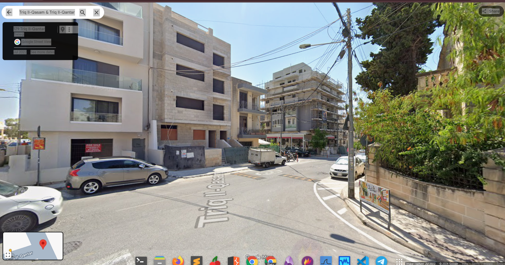
One thing almost threw me off. The Street View was from July 2022 and the background building was still under construction — scaffolding, exposed walls, incomplete. In the challenge image it was fully built and finished.
But I looked at the permanent features — road geometry, junction shape, bollard positions, corner wall structure. All identical. The building just got completed after the Street View was captured. Road geometry never lies.
Alan Found — Extracting the Flag
Junction confirmed. I right-clicked on the exact spot in Google Maps, copied the coordinates, and rounded them down to two decimal places as the flag format required.
Location — the junction of Triq Il-Qasam and Triq Il-Qantar, right outside Sedalicious Beauty Salon, Swieqi, Malta. Alan found. Fabio can rest easy. Challenge solved.
Key Takeaways
Final Thoughts
This was my first CTF and my first GEOINT challenge. I had no idea what I was doing when I started. No methodology, no experience, no tools lined up. Just an image and the question — where is this?
I opened the image, focused on that notable background building, cross-checked with multiple AIs, manually compared country after country, scrolled through several Malta building images until one felt close enough, used that location to find the right neighbourhood on Google Maps, and then virtually walked every road around it in Street View until I hit the exact junction — right outside Sedalicious Beauty Salon on Triq Il-Qasam, Swieqi.
One long chain of observations, wrong turns, small leads, and eliminations. That's what solved it.
That's OSINT. No single correct path. You observe, hypothesise, eliminate, verify. Repeat until certain.
No exploits. No brute force. Just curiosity, patience, and a lot of scrolling.
— VARUN SINGH · VRUNSEC.IN · TEAM KVARMOUR